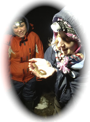
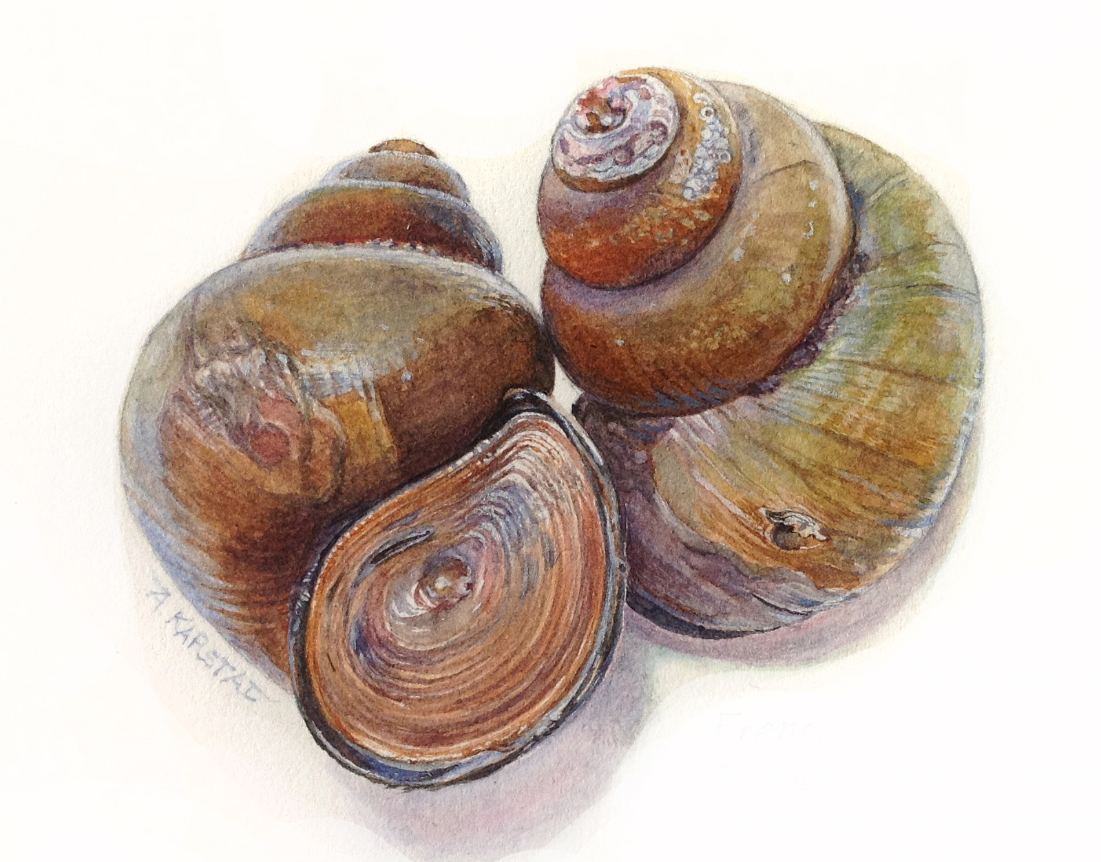
<?xml version="1.0" encoding="UTF-8"?>
<rss version="2.0"
	xmlns:content="http://purl.org/rss/1.0/modules/content/"
	xmlns:wfw="http://wellformedweb.org/CommentAPI/"
	xmlns:dc="http://purl.org/dc/elements/1.1/"
	xmlns:atom="http://www.w3.org/2005/Atom"
	xmlns:sy="http://purl.org/rss/1.0/modules/syndication/"
	xmlns:slash="http://purl.org/rss/1.0/modules/slash/"
	>

<channel>
	<title>Doing Natural History</title>
	<atom:link href="http://www.doingnaturalhistory.com/?feed=rss2" rel="self" type="application/rss+xml" />
	<link>http://www.doingnaturalhistory.com</link>
	<description>Stewardship through art and science</description>
	<lastBuildDate>Sat, 10 Nov 2012 05:38:47 +0000</lastBuildDate>
	<language>en-US</language>
	<sy:updatePeriod>hourly</sy:updatePeriod>
	<sy:updateFrequency>1</sy:updateFrequency>
	<generator>http://wordpress.org/?v=3.5.1</generator>
		<item>
		<title>The Study of Species At Risk &#8211; our experience</title>
		<link>http://www.doingnaturalhistory.com/?p=99</link>
		<comments>http://www.doingnaturalhistory.com/?p=99#comments</comments>
		<pubDate>Fri, 02 Mar 2012 03:01:40 +0000</pubDate>
		<dc:creator>pinicola</dc:creator>
				<category><![CDATA[Uncategorized]]></category>

		<guid isPermaLink="false">http://www.doingnaturalhistory.com/?p=99</guid>
		<description><![CDATA[Presented by Aleta Karstad at the Eastern Ontario Stewardship Forum at the Rideau Valley Conservation Authority headquarters in Manotick, Ontario, on 29 February 2012 I am the artist/naturalist administrative partner of what my husband Dr Frederick W. Schueler calls &#8220;a mom and pop research institute&#8221;, the Bishops Mills Natural History Centre. We manage the e-mail [...]]]></description>
				<content:encoded><![CDATA[<p><a href="http://www.doingnaturalhistory.com/wp-content/uploads/2012/03/ligumianasutaphoto.jpg"><img class="size-medium wp-image-100 alignleft" style="margin-top: 5px; margin-bottom: 5px; margin-left: 15px; margin-right: 15px;" title="ligumianasutaphoto" src="http://www.doingnaturalhistory.com/wp-content/uploads/2012/03/ligumianasutaphoto-289x300.jpg" alt="" width="289" height="300" /></a></p>
<p><span style="font-style: italic;">Presented by Aleta Karstad at the Eastern Ontario Stewardship Forum at the Rideau Valley Conservation Authority headquarters in Manotick, Ontario, on 29 February 2012</span></p>
<p>I am the artist/naturalist administrative partner of what my husband Dr Frederick W. Schueler calls &#8220;a mom and pop research institute&#8221;, the Bishops Mills Natural History Centre. We manage the e-mail listserve, Eastern Ontario NatureList. The blog that shares my paintings and our combined nature journals is <a href="http://www.aletakarstad.com">www.aletakarstad.com</a>. I am also the President of <a href="http://fragileinheritance.org">Fragile Inheritance Natural History</a>, a not-yet incorporated ngo. Fred has built a natural history database of 100,000 records and growing, for which he&#8217;s looking for collaborators to transform it into a web portal.</p>
<p>I am here to address the problem of unseasonable government funding for the study of species at risk. First I will give a brief summary which Fred has drawn up, by decade, of our involvement with species at risk from the 1970&#8242;s to the present, and then I will discuss the sad waste of government funds, and of time and resources, and suggest a way of working toward a solution.</p>
<p><strong>1970&#8242;</strong>s &#8211; finding two of the outlying populations of Butler&#8217;s Garter Snake, filling 5-gallon drums with road-killed Fox Snakes, mapping Chorus Frogs across New York and northern Ontario, checking out Massasuagas and &#8220;Lake Erie Water Snakes&#8221; on Manitoulin&#8230; largely just encountering what turned out to be rare species in the course of museum collecting, general exploration, and chasing particular projects that weren&#8217;t motivated by the rarity of the subjects&#8230;</p>
<p><strong>1980</strong>&#8216;s: wrote the COSEWIC report for Hognose Snake, found the second Ontario aquatic fern <em>Azolla</em>, Musk Turtle in Kemptville Creek, set up conditions for testing range expansion in Butler&#8217;s Garter Snake&#8230; passed up an opportunity to write a book about Endangered Species and made it into the ecological impact of People on the whole continent, since these were so much more easily observed than the Endangered Species.</p>
<p><strong>1990</strong>&#8216;s: did the herpetology of the outer Bruce Peninsula, documented the Lake Ontario Waterfront, worked out a model for rarity in Pickerel Frogs, found Blanding&#8217;s Turtles around home and modelled them as the result of return of Beavers in the 1960&#8242;s, discovered Leopard Frogs were gone from NE Ontario, noticed Chorus Frogs disappearing around home, started chasing the regionally rare Unionids, noticing <em>Ligumia nasuta</em> melt away, and vastly expanding the known range of <em>Obovaria olivaria</em>.</p>
<p><strong>2000</strong>&#8216;s: co-revised the COSEWIC report for Chorus Frogs, expanding understanding of the Quebec declines across non-Carolinean Ontario, joined the Freshwater Mussel Recovery Team, discovered the only remaining secure population of Ligumia nasuta, worked out abundance of Potamilus alatus and Leptodea fragilis on the Ontario side of the Ottawa River, and of Alasmidonta marginata in eastern Ontario. began to apply for SAR funding, but were rebuffed in every application, except an emasculated bittern-painting raffle&#8230;</p>
<p><strong>2010</strong>&#8216;s: working with Conservation Authorities and NGO&#8217;s as part of their applications &#8211;  finally an application for a project we could help with was approved, but high water levels made it impracticable, and no SAR were found. We applied for funding in 2011 with an NGO to survey the only remaining secure population of the COSEWIC-endangered Ligumia nasuta&#8230;  Confident that the initial quantitative survey of this only secure population of a formerly abundant species would be granted, we waited all summer to hear that it was denied funding two days after the date of the end of the proposed field work. We spent the field season interviewing potential Science Horizons interns and finally had to tell the successful candidate that the project was not going ahead.</p>
<p>We all know that there are grave defects in the funding of ecological, conservation, and natural history research in the modern era. One of these defects is one that could be quite easily remedied: the apparently increasing tendency for funding agencies to delay the release or denial of funds for a project, or of required permits, until after the season when the field work ought to have been done. As we all know, this wastes the applicants&#8217; time by not being able to commit to other activities during the delay, and the funder&#8217;s money when the work can&#8217;t be done in the appropriate season.</p>
<p>We actually benefited a couple of times from late receipt of funding &#8211; once when a summer-long survey of species at risk collapsed into a series of public articles and a contest to win an original painting by myself. A second instance of this occurred when funding for determining what species at risk were in an area didn&#8217;t come until October, and for that money Fred and a colleague spent a few weeks working out the species that ought to be found there, or were already in the NHIC database, without any hope of seeing any of these hibernating or migratory species.</p>
<p>When we recount an instance of this problem, other people confirm the seriousness of the issue with their own verbal accounts of similar situations, but never in writing. We are sure that the phenomenon is real, but we can&#8217;t provide extensive documentation. Tom Spears, environmental reporter for the Ottawa Citizen, expressed interest in this phenomenon of unseasonable funding, but the organizations that we&#8217;d known were victims of it were afraid to talk to the press, for fear of losing future funding, and others he talked to denied the phenomenon existed, though we&#8217;d known that at least one of these had been a victim.</p>
<p>Fred and I have tried to work around this &#8220;grave defect&#8221; by no longer expecting to depend on applied-for funding for our work. Our way of sidestepping the funding issues is &#8220;sponsored nomadism&#8221; where an agency or NGO promotes our blog and sale of &#8220;daily paintings,&#8221; to support the exploration which we feel is most important. This model has supported our work at New Brunswick Museum Bioblitzes in 2010 and 2011, and pursuing surviving &amp; extirpated populations of Mussels, among other subjects, in the South Nation drainage in 2011.</p>
<p>But the waste goes on. How many times has this happened to you? I don&#8217;t blame you for not filing complaints, as no one wants to jeopardize future funding. Can we voice the issue as a larger group with the common goal of demanding timely and effective funding for Species At Risk? I hope that the meetings today will result in some next steps on this.</p>
]]></content:encoded>
			<wfw:commentRss>http://www.doingnaturalhistory.com/?feed=rss2&#038;p=99</wfw:commentRss>
		<slash:comments>0</slash:comments>
		</item>
		<item>
		<title>Climbing Poison Ivy in eastern Ontario!</title>
		<link>http://www.doingnaturalhistory.com/?p=68</link>
		<comments>http://www.doingnaturalhistory.com/?p=68#comments</comments>
		<pubDate>Thu, 25 Feb 2010 10:56:14 +0000</pubDate>
		<dc:creator>admin</dc:creator>
				<category><![CDATA[Projects]]></category>

		<guid isPermaLink="false">http://www.doingnaturalhistory.com/?p=68</guid>
		<description><![CDATA[On 23 February an errand took us down a small gravel road off County road #1 in Stormont Dundas &#38; Glengarry County, a few kilometres south of Mountain, Ontario. Fred noticed a telephone pole with a Poison Ivy vine climbing up it right to the height of the wires, so on our way back out, [...]]]></description>
				<content:encoded><![CDATA[<p style="text-align: center;">
<p>On 23 February an errand took us down a small gravel road off County road #1 in Stormont Dundas &amp; Glengarry County, a few kilometres south of Mountain, Ontario.  Fred noticed a telephone pole with a Poison Ivy vine climbing up it right to the height of the wires, so on our way back out, we stopped to take photos and break off a specimen.</p>
<p>I have only seen the climbing kind of Poison Ivy a couple of times north of the US.  Once on the Bruce Trail near Collingwood, and once in Toronto.  The thing I find most sinister about Poison Ivy vines, is the way the stems are fastened tightly to the tree trunk (or telephone pole in this case) by dense red fringes of aerial roots with the kind of aggressive vigour that one would only expect in highly competitive and diverse tropical forests! This one had plenty of tufts of reddish rootlets embroidering its multiple grey vine stems to the pole, but the spookiest thing was the way that a few of the thickest stems emerged from the top of a metal tube that was fastened to the side of the pole.  They filled the tube nearly to bursting and seemed to explode from the opening, reaching its several tips to nearly touch the telephone wires.</p>
<p>This vine must have been splendid with clusters of white berries this fall, as now every branch-tip is decorated with the delicate skeletons of bare fruiting stems. I took several photos. We will return to check it in the growing season.</p>
]]></content:encoded>
			<wfw:commentRss>http://www.doingnaturalhistory.com/?feed=rss2&#038;p=68</wfw:commentRss>
		<slash:comments>4</slash:comments>
		</item>
		<item>
		<title>30 Years Later</title>
		<link>http://www.doingnaturalhistory.com/?p=51</link>
		<comments>http://www.doingnaturalhistory.com/?p=51#comments</comments>
		<pubDate>Sat, 06 Feb 2010 22:09:55 +0000</pubDate>
		<dc:creator>admin</dc:creator>
				<category><![CDATA[Projects]]></category>
		<category><![CDATA[30 Years Later]]></category>
		<category><![CDATA[art]]></category>
		<category><![CDATA[travel]]></category>

		<guid isPermaLink="false">http://www.doingnaturalhistory.com/?p=51</guid>
		<description><![CDATA[Our 'big project' for 2010, revisiting and recataloging many of the sites we've visited over the last three decades]]></description>
				<content:encoded><![CDATA[<p style="text-align: left;"><a href="http://www.doingnaturalhistory.com/wp-content/uploads/2010/02/30YearsLogo.jpeg"><img class="aligncenter size-full wp-image-58" title="30YearsLogo" src="http://www.doingnaturalhistory.com/wp-content/uploads/2010/02/30YearsLogo.jpeg" alt="" width="268" height="124" /></a></p>
<p style="text-align: left;">The <strong>30 Years Later Expedition</strong> a trans-Canada biological survey in celebration of the <a href="http://www.cbd.int/2010/welcome/" target="_blank">International Year of Biodiversity</a>, and in partnership with the <a title="Canadian Museum of Nature" href="http://www.nature.ca" target="_blank">Canadian Museum of Nature</a>, will embark in March of 2010 to cross Canada from coast to coast. We&#8217;ll  revisit the landscape we have traveled over the past 30 years, surveying species, describing, sketching and painting.</p>
<p>During a full year of travel, the 30 Years Later Expedition will revisit and check the condition of ecological communities and populations of plants and animals, some of them now Species At Risk. <a title="Karstad Art" href="http://www.aletakarstad.com" target="_blank">Aleta</a> will paint and draw enroute as Fred adds valuable new data to historical records, in a database partnership with the Canadian Museum of Nature.</p>
<p>A rare long term study in an age of short term projects, 30 Years Later welcomes contributions from amateur naturalists and scientists, to suggests and add to our itinerary of revisits across Canada. We invite everyone to meet us enroute, to see what we&#8217;ve found, and participate in the biological survey &#8211; an important baseline for the study of ecology and the environment in Canada.</p>
<p style="text-align: center;"><img src="http://pinicola.ca/thirty/flickerhead300.jpg" alt="[Yellow Shafted Flicker painting by Aleta Karstad]" width="225" height="197" align="TOP" /></p>
<p>Click <a title="30 Years Later homepage" href="http://www.pinicola.ca/thirty" target="_blank">here</a> to visit the project&#8217;s homepage.</p>
]]></content:encoded>
			<wfw:commentRss>http://www.doingnaturalhistory.com/?feed=rss2&#038;p=51</wfw:commentRss>
		<slash:comments>2</slash:comments>
		</item>
		<item>
		<title>Observing Giant Urban Slugs</title>
		<link>http://www.doingnaturalhistory.com/?p=37</link>
		<comments>http://www.doingnaturalhistory.com/?p=37#comments</comments>
		<pubDate>Sat, 06 Feb 2010 20:31:04 +0000</pubDate>
		<dc:creator>admin</dc:creator>
				<category><![CDATA[Projects]]></category>
		<category><![CDATA[30 Years Later]]></category>
		<category><![CDATA[art]]></category>
		<category><![CDATA[slugs]]></category>

		<guid isPermaLink="false">http://www.doingnaturalhistory.com/?p=37</guid>
		<description><![CDATA[In November I received an e-mail from a resident of Etobicoke, asking for information about large pumpkin coloured slugs encountered on a sidewalk as she walked her daughter to school. It seems that my paintings of live slugs, native and introduced, and my recent training and mentoring by  Swiss slug expert Ulrich Schnepatt, has made [...]]]></description>
				<content:encoded><![CDATA[<p>In November I received an e-mail from a resident of Etobicoke, asking for information about large pumpkin coloured slugs encountered on a sidewalk as she walked her daughter to school.</p>
<p>It seems that my paintings of live slugs, native and introduced, and my recent training and mentoring by  Swiss slug expert Ulrich Schnepatt, has made me the Canadian specialist in this case! Not only did I receive a shipment of the slugs in question to observe, photograph, preserve, and dissect in the process of discovering their identity, but a cascade of excitement about giant slugs ensued!</p>
<p>First, I was contacted by a writer for the Toronto Star, and we got an excellent article written about the mysterious new-to-science occurrence of giant orange slugs in Toronto. You can read the article <a href="http://www.thestar.com/news/sciencetech/article/727232--10-cm-etobicoke-slug-a-big-slimy-mystery?bn=1" target="_blank">here</a>.</p>
<p>Immediately a steady stream of e-mails began (totalling 30 in two weeks), reporting sightings of giant slugs of two kinds (the big Arion, and the Leopard Slug, Limax maximus) from Oakville to Bowmanville, and Rockwood to Wiarton &#8211; even one from Sudbury!  One from Croatia, and a photo taken in England.</p>
<p>In the midst of this excitement, the Royal Ontario Museum contacted me, asking for specimens, and Canadian Geographic Magazine plans to feature the public interest in these exotic creatures with a feature on citizen science in the June issue.</p>
<p>Our friend Kari Gunson, the road ecologist, made a map for me of all the localities reported in everyone&#8217;s e-mails, and it looks like this:</p>
<p><a title="slugmap600" href="http://farm3.static.flickr.com/2790/4327104336_9da902220f_o.jpg"><img src="http://farm3.static.flickr.com/2790/4327104336_9da902220f_o.jpg" alt="slugmap600" width="600" height="464" /></a></p>
<p>I have thoroughly enjoyed the first stage of this investigation, and invite everyone to participate &#8211; put your slugs on the map!  The next stage will be site visits in the summer of 2010, to photograph and collect.</p>
<p>Slugs are fascinating, and GIANT slugs are astonishing!  I have been watching them explore their surroundings, eat, and grow &#8211; and even lay eggs.  Presently Philip and I are drawing and photographing the development of tiny slug embryos in clear-as-glass Limax eggs.</p>
<p>If you see a slug that is 5 centimetres or more, collect it or photograph it, send me a comment on this blog or e-mail me, <A HREF="mailto:karstad@pinicola.ca">Aleta Karstad</A> - and together we&#8217;ll find out who these European introductions are, and how far they have spread.</p>
<p>I&#8217;ll see you all in the summer, as we re-visit all the places we&#8217;ve been across Ontario in the first stage of the 30 Years Later Expedition.</p>
<p>To see more of our slug project, visit <a href="http://www.pinicola.ca/slugwork.htm" target="_blank">www.pinicola.ca/slugwork.htm</a></p>
]]></content:encoded>
			<wfw:commentRss>http://www.doingnaturalhistory.com/?feed=rss2&#038;p=37</wfw:commentRss>
		<slash:comments>8</slash:comments>
		</item>
		<item>
		<title>How to find edible wild plants</title>
		<link>http://www.doingnaturalhistory.com/?p=33</link>
		<comments>http://www.doingnaturalhistory.com/?p=33#comments</comments>
		<pubDate>Tue, 19 Jan 2010 21:19:04 +0000</pubDate>
		<dc:creator>admin</dc:creator>
				<category><![CDATA[How-to...]]></category>

		<guid isPermaLink="false">http://www.doingnaturalhistory.com/?p=33</guid>
		<description><![CDATA[Some notes following a session of teaching edible wild plants to campers]]></description>
				<content:encoded><![CDATA[<p><span style="font-size: small;"> </span></p>
<p><span style="font-size: small;">========================================================== </span></p>
<p><span style="font-size: small;">Field notes of Frederick W. Schueler &#8211; 14 August 2002 </span></p>
<p><span style="font-size: small;">========================================================== </span></p>
<p><span style="font-size: small;"> </span></p>
<p><span style="font-size: small;">Canada: Ontario: Leeds County: Rear of Leeds &amp; Landsdowne Township: </span><strong><span style="font-size: small;">Lyndhurst, Camp Hyanto</span></strong><span style="font-size: small;">. 31C/9, UTM 18TVE 110  334,  44.55043N 76.12010W.  TIME: 1230-1700. AIR TEMP: about 33C, sunny, breezy. HABITAT: Red Oak/White Pine church camp slope, Sugar Maple woods, cemetery, weedy lake. OBSERVER: Frederick W. Schueler, Bill Kilfoyle, Hyanto Staff &amp; campers. 2002/181/b, </span><strong><span style="font-size: small;">visit</span></strong><span style="font-size: small;">. teaching edible wild plants to campers.  This year Camp Hyanto, the Anglican summer camp which we first visited when Rose van der Ham was camp manager in 1996-1997, wound up the summer session with a &#8216;survival&#8217; week that set out to teach the campers (of both sexes) the he-manly skills of co-operation and wilderness adeptness. </span></p>
<p><span style="font-size: small;"> </span></p>
<p><span style="font-size: small;">Bill Kilfoyle, doubtless remembering that we stuck him with writing the celebrity blurb for our Lawn Care Manual, had asked me to instruct the campers on the subject of edible wild plants, so he picked me up at 10h20, and I showed him the optimal route between Bishops Mills and Lyndhurst (Buker, Bolton, Branch, North Augusta, Fly Creek, Jellyby=Greenbush=Addison rds, Highway 42, County Road 33). </span></p>
<p><span style="font-size: small;"> </span></p>
<p><span style="font-size: small;">My presentation was to be one third of the afternoon&#8217;s programme, so upon our arrival Bill &amp; I wandered the paths around the camp, checking out the fibrous and wilted potential for teaching wild plants.  After a dining hall lunch of macaroni &amp; cheese with dip &amp; vegetables and lemonade, we sat around in the hot breeze for the campers &#8216;siesta&#8217; (which was enlivened by toned-down performances of risque Girl Guide songs, and interrupted only by the ambulance removal of one camper who&#8217;d suffered sunstroke on a canoe trip). </span></p>
<p><span style="font-size: small;"> </span></p>
<p><span style="font-size: small;">After all this sitting around I addressed three separate thirds of the camp (colourfully denominated Group 1, Group 2 and Group 3), each for only about half an hour.  One never knows how to begin these talks: instructor from planet Zargon facing off against instructees from planet Zork.  How much of the contemporary media/ government/ religion/ school-propagated caricature of the anthropocentric commercial consumerist does one want to assume in the audience?  And if they hew to this nominally popular creed, how much interest are they supposed to show in what I&#8217;ve got to say? For me teaching about eating local greenery is like teaching breathing (&#8216;okay, first you depress the diaphragm while relaxing the intercostal muscles&#8230;&#8217;), while some of these kids, it turns out, didn&#8217;t even know that Blackberries turned reddish as they ripened, or were black when ripe.  On the other hand, about 10% affirmed that they ate Dandelions at home. </span></p>
<p><span style="font-size: small;"> </span></p>
<p><span style="font-size: small;">So for each group I tried to hit a couple of theoretical high points of herbivory before we went out for a walk: </span></p>
<p><span style="font-size: small;"> </span></p>
<p><span style="font-size: small;">1) that one couldn&#8217;t very well learn to eat wild plants for the sake of rare survivalist events, since there were so many species to know, and each part of each species was </span><span style="font-size: small;">vulnerable to human consumption for such a brief season.  Better that one lived with one&#8217;s flora, using what one could, as a matter of gustatory delight and of integration with one&#8217;s environment.  And the way to learn about the edibility of species (assuming parental ignorance) was by immersion in some of the excellent books on the subject, especially Lee Allen Peterson&#8217;s Field Guide.  I proposed that an appropriate measure of the human standard of living is the percentage of one&#8217;s diet uncultivated plants comprise, as a sign of the freedom one has to harvest them&#8230; </span></p>
<p><span style="font-size: small;"> </span></p>
<p><span style="font-size: small;">2) that since wild plants live for themselves, their universal goal is to minimize herbivory, unlike cultivated varieties that have been artificially selected for tender tastiness; that the defences of the wild plants are largely flavour and fibre (spine-defended species weren&#8217;t conspicuous), and that every flavour is the plant&#8217;s attempt to be toxic to some herbivore, and that mincing, mixing and cooking were our responses to these defenses, and these same responses were employed by foraging ruminants (television entertainment was invented, after all, only as a sop to those who didn&#8217;t have the opportunity to watch Goats forage)&#8230; </span></p>
<p><span style="font-size: small;"> </span></p>
<p><span style="font-size: small;">Since the times were short, and there were relatively small amounts of some species available, each group visited a different mix of species.   The campers showed a striking enthusiasm for eating these late-summer productions, defended by fibre and secondary plant compounds, including what I&#8217;d have regarded as sub-palatable stages of leaf and fruit&#8230;. </span></p>
<p><span style="font-size: small;"> </span></p>
<p><span style="font-size: small;">SPECIES LIST:</span></p>
<p><span style="font-size: small;"> </span></p>
<p><em><span style="font-size: small;">Typha x glauca</span></em><span style="font-size: small;"> (Hybrid Cattail),  dominant along shore of Lyndhurst Lake in tough mats &#8211; torn apart and softer bits devoured by campers; </span></p>
<p><em><span style="font-size: small;">Vitis riparia</span></em><span style="font-size: small;"> (Frost Grape),  leaves eagerly eaten &#8211; ripe fruit and green devoured like M &amp; M candies; </span></p>
<p><em><span style="font-size: small;">Taraxacum officinale</span></em><span style="font-size: small;"> (Common Dandelion),  wilty tough leaves willingly eaten; </span></p>
<p><em><span style="font-size: small;">Plantago major</span></em><span style="font-size: small;"> (Broad-leaved Plantain),  tough leaves sampled with Dandelions; </span></p>
<p><em><span style="font-size: small;">Oxalis acetosella</span></em><span style="font-size: small;"> (Wood-sorrel),  eagarly eaten; </span></p>
<p><em><span style="font-size: small;">Juglans cinerea</span></em><span style="font-size: small;"> (Butternut),  half-ripe fruit from one healthy tree passed around and sniffed; </span></p>
<p><em><span style="font-size: small;">Hemerocallis fulva</span></em><span style="font-size: small;"> (Day Lily),  tough leaves chewed on &amp; pronounced &#8216;not bad&#8217;; </span></p>
<p><em><span style="font-size: small;">Arctium minus</span></em><span style="font-size: small;"> (Common Burdock),  leaves willingly eaten as an example of a chemically defended plant; </span></p>
<p><em><span style="font-size: small;">Rubus cf canadensis</span></em><span style="font-size: small;"> (Canada Blackberry),  fruit wildly popular; </span></p>
<p><em><span style="font-size: small;">Smilax herbacea</span></em><span style="font-size: small;"> (Carrion Flower),  noted in a thicket but not sampled; </span></p>
<p><em><span style="font-size: small;">Quercus borealis</span></em><span style="font-size: small;"> (Red Oak),  common with moderate acorn crop; </span></p>
<p><em><span style="font-size: small;">Carya cordiformis</span></em><span style="font-size: small;"> (Bitternut Hickory),  saplings common in understorey &#8211; some adult trees with green nuts; </span></p>
<p><em><span style="font-size: small;">Juglans nigra</span></em><span style="font-size: small;"> (Black Walnut),  saplings growing as if feral or wild. </span></p>
<p><span style="font-size: small;"> </span></p>
<p><span style="font-size: small;">&#8230;and this list doesn&#8217;t include many species that I discussed and pointed out as edible, but weren&#8217;t eaten. </span></p>
<p><span style="font-size: small;">published as: Schueler, Frederick W. 2004. Surviving at Camp. Burnt Toast 2(2):7-8.</span></p>
]]></content:encoded>
			<wfw:commentRss>http://www.doingnaturalhistory.com/?feed=rss2&#038;p=33</wfw:commentRss>
		<slash:comments>1</slash:comments>
		</item>
		<item>
		<title>How to take a trip</title>
		<link>http://www.doingnaturalhistory.com/?p=27</link>
		<comments>http://www.doingnaturalhistory.com/?p=27#comments</comments>
		<pubDate>Tue, 19 Jan 2010 21:05:36 +0000</pubDate>
		<dc:creator>admin</dc:creator>
				<category><![CDATA[How-to...]]></category>
		<category><![CDATA[GPS]]></category>
		<category><![CDATA[travel]]></category>

		<guid isPermaLink="false">http://www.doingnaturalhistory.com/?p=27</guid>
		<description><![CDATA[For those who rejoice in the reality of the world, the sadness of modern transportation is almost overwhelming. Literal myriads rush, every day, between thousands of places without noticing or recording what they&#8217;ve driven past, and even those who would rather move at a better-documented pace are often hurried along by pressing obligations. Unless in [...]]]></description>
				<content:encoded><![CDATA[<p>For those who rejoice in the reality of the world, the sadness of modern transportation is almost overwhelming. Literal myriads rush, every day, between thousands of places without noticing or recording what they&#8217;ve driven past, and even those who would rather move at a better-documented pace are often hurried along by pressing obligations. Unless in a serious emergency, a single-purpose trip is always partially wasted. Such a trip desecrates the places visited by burning fossil fuel and taking up human time for a purely ephemeral end.</p>
<p>As we all drive along, we each make hundreds of species-level identifications every minute, and we think, or should be thinking, about the landscape, biotic, and cultural patterns that these organisms are affected by or participate in. If these thoughts are framed, as they ought to be, as falsifiable hypotheses, today&#8217;s patterns and the changes the hypotheses predict need to be preserved so that the present distribution of species can be documented, and the usefulness of the hypotheses can be tested.  Every routine or repeated trip should acquire some long-term data, both to test hypotheses and to offset the human incapacity for noticing gradual change, and every irregular trip should explore and document the distribution of some species or phenomenon or the characteristics of some site. No one is likely to ever meet all these high goals, but if they are not kept in mind they are not going to be met accidentally.</p>
<p>In September 2006 I had the opportunity to take a relatively unhurried trip to Syracuse, New York, to visit family, and I&#8217;ve annotated the narrative of this trip as an example of our methods, continuing the series of Trail &amp; Landscape articles outlining our techniques (Schueler, F.W., Aleta Karstad, Jamie Proctor, &amp; Ryan Hawke. 2007. How to ‘do’ a bridge. T&amp;L 41(1):38-49; Schueler, F.W. 2000. Navigating as Naturalists with the Global Positioning System. T&amp;L 34(1):35-40; Karstad, Aleta. 2000. Drawing from Life. T&amp;L 34(3):110-116).</p>
<p>Geographic co-ordinates in the following narrative (all in WGS 84 datum) are a combination of new waypoints (Garmin eTrex Legend) and previously recorded locations. The co-ordinates can be used to view the sites on google maps, or other internet map systems, by inserting the decimal degrees as the location (e.g. 44.87156°N 75.70095°W for a nice view of our backyard).<br />
<span style="font-size: x-small;">===================</span><span style="font-size: x-small;">======================================= </span></p>
<p><span style="font-size: medium;">EOBase Narrative: 1 September 2006 </span><a name="_ftnref1"></a><a href="https://docs.google.com/Doc?docid=0AZSrl3SAbSReZHh6azM4eF8xN2c0cTc3Y2cz&amp;hl=en#_ftn1">[1]</a></p>
<p><span style="font-size: x-small;">========================================================== </span></p>
<p><span style="font-size: x-small;">(at home: </span><span style="font-size: x-small;">Canada: Ontario: Grenville County: Oxford-on-Rideau: </span><strong><span style="font-size: x-small;">Bishops Mills, S side (Schuelers)</span></strong> <span style="font-size: x-small;">31B/13, 44.87156°N 75.70095</span><span style="font-size: x-small;">°</span><span style="font-size: x-small;">W).</span><span style="font-size: x-small;"> TIME: 1707 (EDT). AIR TEMP: 22</span><span style="font-size: x-small;">°C</span><span style="font-size: x-small;">, sunny, Beaufort moderate breeze. HABITAT: rural village, shallow soil limestone plain. OBSERVER: Frederick W. Schueler, Aleta Karstad Schueler. 2006/173/d, </span><em><span style="font-size: x-small;">Corvus corax</span></em><span style="font-size: x-small;"> (Raven) (Bird). 1 calling, heard, seen. </span><em><span style="font-size: x-small;">&#8216;ark-ark-ark&#8217;</span></em><span style="font-size: x-small;"> calls, seen flying low S of village. </span></p>
<p><span style="font-size: x-small;"> </span></p>
<p><strong><em><span style="font-size: x-small;">* we never heard or saw Ravens in Grenville County until the early 1990&#8242;s, so in order to track patterns in their activities, both secular and seasonal, we record every Raven we see or hear.</span></em></strong></p>
<p><span style="font-size: x-small;"> </span></p>
<p><span style="font-size: x-small;">(same location) TIME: 1743. AIR TEMP: 21</span><span style="font-size: x-small;">°C</span><span style="font-size: x-small;">, cloudy, Beaufort gentle breeze. OBSERVER: Frederick W. Schueler. focuslog, </span><strong><span style="font-size: x-small;">departure</span></strong><span style="font-size: x-small;"> (event). natural history, drive. 171406 km, to Syracuse. </span><span style="font-size: x-small;">ROUTE: Buker, Bolton. Kyle, Branch, N. Augusta rds, Highway 401, I81, I481, I690, Midler Ave, etc</span></p>
<p><span style="font-size: x-small;"> </span></p>
<p><span style="font-size: x-small;">moved 3.4 km SSW. </span></p>
<p><span style="font-size: x-small;"> </span></p>
<p><span style="font-size: x-small;">Wolford: </span><strong><span style="font-size: x-small;">Bolton Road, 3 km SSW Bishops Mills</span></strong><span style="font-size: x-small;">.  44.84266°N 75.71578</span><span style="font-size: x-small;">°</span><span style="font-size: x-small;">W. TIME: 1755. AIR TEMP: 21</span><span style="font-size: x-small;">°C</span><span style="font-size: x-small;">, cloudy, Beaufort gentle breeze. HABITAT: road through Thuja woods &amp; planted Jack Pine barrens. 2006/173/e, </span><strong><span style="font-size: x-small;">no observation</span></strong><span style="font-size: x-small;"> (event). survey, driveby. </span><strong><span style="font-size: x-small;">NO:Lepus americanus</span></strong><span style="font-size: x-small;"> AOR/DOR, road newly graded &amp; gravelly. </span></p>
<p><span style="font-size: x-small;"> </span></p>
<p><strong><em><span style="font-size: x-small;">* N</span></em></strong><strong><em><span style="font-size: x-small;">umbers of Snowshoe Hares,</span></em></strong> <strong><span style="font-size: x-small;">Lepus americanus,</span></strong><strong><em><span style="font-size: x-small;"> wax and wane in the </span></em></strong><strong><em><span style="font-size: x-small;">famous ten-year cycle of boreal wildlife.  It’s astonishing enough that Hare populations should cycle with this regularity. But it’s more astonishing that these cycles should be synchronous within 1-2 years all across boreal Canada and Alaska, and even more astonishing that they should be “highly positively correlated (P&lt;.0001) with sunspot maxima 4 yr previously” (</span></em></strong><strong><em><span style="font-size: x-small;">Sinclair, et al. 1993. Can the solar cycle and climate synchronize the snowshoe hare cycle in Canada? Evidence from tree rings and ice cores. American Naturalist 141(2)173-198. </span></em></strong><a href="http://hdl.handle.net/1807/443"><strong><em><span style="font-size: x-small;">http://hdl.handle.net/1807/443</span></em></strong></a> <strong><em><span style="font-size: x-small;">) It seems that the cycles result from the Hares’ interactions with food supply and predators, synchronized across the continent by weather differences that result from the sunspot cycle.  Since we’ve been living in Bishops Mills, there have been sunspot maxima in 1979, 1989, and 2000, each followed by a decline in Hare populations within a few years. The best place to see Hares is on the south end of Bolton Road, through the Cedar woods and Jack Pine plantations of Limerick Forest</span></em></strong><strong><em><span style="font-size: x-small;">, and we monitor their abundance by counting the number we see each time we drive this road on the way to North Augusta or Brockville. </span></em></strong></p>
<p><span style="font-size: x-small;"> </span></p>
<p><span style="font-size: x-small;">moved 22.0 km S. </span></p>
<p><span style="font-size: x-small;"> </span></p>
<p><span style="font-size: x-small;">Ontario: Leeds County: Elizabethtown: </span><strong><span style="font-size: x-small;">Long Swamp at N. Augusta Road</span></strong><span style="font-size: x-small;">. 31B/12, 44.64468°N 75.70452°W. TIME: 1818. AIR TEMP: circa 20</span><span style="font-size: x-small;">°C</span><span style="font-size: x-small;">, cloudy, breezy. HABITAT: road through flooded Red Maple swamp. 2006/173/f, </span><strong><span style="font-size: x-small;">visit</span></strong><span style="font-size: x-small;"> (event). survey, driveby. very green, including bed of pools with no visible water. </span></p>
<p><span style="font-size: x-small;"> </span></p>
<p><strong><em><span style="font-size: x-small;">* this is the site where the late Mike Rankin first noticed terrestrial amplexus in Wood Frogs (</span></em></strong><strong><span style="font-size: x-small;">Rana sylva</span></strong><strong><span style="font-size: x-small;">tica; </span></strong><strong><em><span style="font-size: x-small;">Schueler, F.W. and R. Michael Rankin 1982. </span></em></strong><strong><em><span style="font-size: x-small;">Terrestrial amplexus in the Wood Frog, </span></em></strong><strong><span style="font-size: x-small;">Rana sylvatica</span></strong><strong><em><span style="font-size: x-small;">.</span></em></strong><strong><em><span style="font-size: x-small;"> Canadian Field-Naturalist 96:348-349</span></em></strong><strong><em><span style="font-size: x-small;">), and</span></em></strong><strong><em><span style="font-size: x-small;"> one of our long-term monitoring sites for the frequency of mid-dorsal striping in Wood Frogs. When the Wood Frogs aren’t breeding, we notice the level of the water in their ponds as an index of regional wetness. In May 2006, and again in 2007, we first saw Geese &amp; goslings (</span></em></strong><strong><span style="font-size: x-small;">Branta canadensis</span></strong><strong><em><span style="font-size: x-small;">) here, standing right along the road only a couple of metres from the traffic.</span></em></strong></p>
<p><span style="font-size: x-small;"> </span></p>
<p><span style="font-size: x-small;">moved 39.8 km SW. </span></p>
<p><span style="font-size: x-small;"> </span></p>
<p><span style="font-size: x-small;">USA: New York: Jefferson County: Orleans: </span><strong><span style="font-size: x-small;">Wellesley Is boundary bridge, US/Canada border</span></strong><span style="font-size: x-small;">. 31B/5,  44.34794°N 75.98413°W. TIME: 1910. AIR TEMP: circa 20</span><span style="font-size: x-small;">°C</span><span style="font-size: x-small;">, cloudy, breezy. HABITAT: US Customs toll gate. 2006/173/g, </span><em><span style="font-size: x-small;">Homo sapiens</span></em><span style="font-size: x-small;"> (Human People) (Mammal). adult, male, drive. &#8220;do you own the car?&#8221;. A new class of Thousand Islands US Customs off-the-wall remark, followed by an inspection of popcorn bags in the back of the car, and an inquiry into the mechanism of action of a plant press. </span></p>
<p><span style="font-size: x-small;"> </span></p>
<p><strong><em><span style="font-size: x-small;">* it has often been speculated, from the erratic questions they ask of travellers, that the US Customs office at the Thousand Islands constitutes an independent Republic of Comedy&#8230;</span></em></strong></p>
<p><span style="font-size: x-small;"> </span></p>
<p><span style="font-size: x-small;">moved 22.1 km SSE. </span></p>
<p><span style="font-size: x-small;"> </span></p>
<p><strong><span style="font-size: x-small;">I81/3.1 km S NY 411</span></strong><span style="font-size: x-small;">. 31B/4, 44.16375°N 75.87956°W. TIME: 1930ca. AIR TEMP: circa 20</span><span style="font-size: x-small;">°C</span><span style="font-size: x-small;">, overcast, breezy. HABITAT: superhwy roadside. 2006/173/h, </span><strong><span style="font-size: x-small;">visit</span></strong><span style="font-size: x-small;"> (event). natural history, drive. wide stretches of roadside have recently been mowed by rotary blades on a tractor, as if making a hayfield into a lawn (though this has been going on for 40 yrs), leaving a tousled blanket of unruly clippings on the wide medians and margins of the highway. This gives a very different effect from the &#8216;let it go&#8217; effect along Ontario series 400 highways, and I81 south of Syracuse, but I haven&#8217;t been paying enough attention to say what&#8217;s really happening along the Ontario highways. Here the mowing comes right up to the individual trees, leaving dense closely mowed-around patches of </span><em><span style="font-size: x-small;">Typha</span></em><span style="font-size: x-small;"> (Cattail) and </span><em><span style="font-size: x-small;">Phragmites</span></em><span style="font-size: x-small;"> (Reed) in the low areas &#8212; but there&#8217;s not much it&#8217;s safe to record when you&#8217;re a single driver four days late for an appointment, or, as my Mother would reckon it, a month or more late. </span></p>
<p><span style="font-size: x-small;"> </span></p>
<p><span style="font-size: x-small;">moved 126.7 km S. </span></p>
<p><span style="font-size: x-small;"> </span></p>
<p><span style="font-size: x-small;">New York: Onondaga County: Syracuse: </span><strong><span style="font-size: x-small;">Finlayson-Schuelers, 118 Shirley Road</span></strong><span style="font-size: x-small;">. 30N/1, 43.03592°N 76.10431°W. TIME: 2104. 2006/173/i, </span><strong><span style="font-size: x-small;">arrival</span></strong><span style="font-size: x-small;"> (event). personal, drive. WAYPT/002, too whoofed to take an air temperature. </span></p>
<p><span style="font-size: x-small;"> </span></p>
<p><span style="font-size: x-small;">========================================================== </span></p>
<p><span style="font-size: x-small;">2 September 2006 </span></p>
<p><span style="font-size: x-small;">========================================================== </span></p>
<p><span style="font-size: x-small;">USA: New York: Onondaga County: Syracuse: </span><strong><span style="font-size: x-small;">Finlayson-Schuelers, 118 Shirley Road</span></strong><span style="font-size: x-small;">. 43.03592°N 76.10431°W. TIME: 1135. AIR TEMP: circa 17</span><span style="font-size: x-small;">°C</span><span style="font-size: x-small;">, steady rain. OBSERVER: Frederick W. Schueler, Theodore Finlayson-Schueler, Jeanne Finlayson-Schueler. 2006/174/-, </span><strong><span style="font-size: x-small;">departure</span></strong><span style="font-size: x-small;"> (event). personal, drive. in Ted &amp; Jeannes&#8217;s car to Cortland. </span></p>
<p><span style="font-size: x-small;"> </span></p>
<p><span style="font-size: x-small;">moved 50.3 km S. </span></p>
<p><span style="font-size: x-small;"> </span></p>
<p><span style="font-size: x-small;">New York: Cortland County: </span><strong><span style="font-size: x-small;">Cortland College football field, 1 km N Munsons Corners</span></strong><span style="font-size: x-small;">. 30K/9,   42.58926°N 76.20255°W. TIME: 1235-1316. AIR TEMP: 16</span><span style="font-size: x-small;">°C</span><span style="font-size: x-small;">, overcast, windy. HABITAT: small-stadium football field. 2006/174/b, </span><strong><span style="font-size: x-small;">visit</span></strong><span style="font-size: x-small;"> (event). personal, sit. WAYPT/003, watched scrimmage including Brian </span><span style="font-size: x-small;">Finlayson-Schueler</span><span style="font-size: x-small;">. </span></p>
<p><span style="font-size: x-small;"> </span></p>
<p><span style="font-size: x-small;">moved 3.3 km NE. </span></p>
<p><span style="font-size: x-small;"> </span></p>
<p><span style="font-size: x-small;">Cortland: </span><strong><span style="font-size: x-small;">W Branch Tioughnioga River, just upstream NY 13 bridge</span></strong><span style="font-size: x-small;">. 42.60678°N 76.16980°W. TIME: 1655-1710. AIR TEMP: 15.5</span><span style="font-size: x-small;">°C</span><span style="font-size: x-small;">, overcast, windy. HABITAT: small clay-turbid gravel-bed river, dense-herb/wooded/parkinglot banks. OBSERVER: Frederick W. Schueler. 2006/174/ca, </span><em><span style="font-size: x-small;">Polygonum cuspidatum</span></em><span style="font-size: x-small;"> (Japanese Knotweed) (Plant). codominant herb, in bloom, seen. dense stands in bloom along banks. This is the 24-hr shopping centre parking lot in Cortland, where we launched the canoes for our trip down the </span><span style="font-size: x-small;">Tioughnioga</span> <span style="font-size: x-small;">in 2003. I walked along the banks looking for drift, in a greenness that hadn&#8217;t been much disturbed by the recent flooding, and to which my meagre notes don&#8217;t do much justice: </span></p>
<p><span style="font-size: x-small;"> </span></p>
<p><span style="font-size: x-small;"> LIST: </span><em><span style="font-size: x-small;">Alliaria petiolata</span></em><span style="font-size: x-small;"> (Garlic Mustard), some among other vegetation at upstream end of area; </span></p>
<p><span style="font-size: x-small;"> </span><em><span style="font-size: x-small;">Solidago</span></em><span style="font-size: x-small;"> (Goldenrod), clumps in bloom on banks; </span></p>
<p><span style="font-size: x-small;"> </span><em><span style="font-size: x-small;">Dipsacus sylvestris</span></em><span style="font-size: x-small;"> (Teasel), scattered plants past bloom; </span></p>
<p><span style="font-size: x-small;"> </span><em><span style="font-size: x-small;">Arctium lappa</span></em><span style="font-size: x-small;"> (Great Burdock), the only burdock species here; </span></p>
<p><span style="font-size: x-small;"> </span><em><span style="font-size: x-small;">Convolvulus</span></em><span style="font-size: x-small;"> (Bindweed), in bloom draped over bushes; </span></p>
<p><span style="font-size: x-small;"> </span><em><span style="font-size: x-small;">Helianthus tuberosus</span></em><span style="font-size: x-small;"> (Jerusalem Artichoke), clumps in bloom; </span></p>
<p><span style="font-size: x-small;"> </span><em><span style="font-size: x-small;">Impatiens capensis</span></em><span style="font-size: x-small;"> (Spotted Jewelweed), in bloom under NY 13 bridge; </span></p>
<p><span style="font-size: x-small;"> </span><em><span style="font-size: x-small;">Impatiens pallida</span></em><span style="font-size: x-small;"> (Pale Jewel-weed), in bloom under NY 13 bridge. </span></p>
<p><span style="font-size: x-small;"> </span></p>
<p><span style="font-size: x-small;">moved 0.3 km ENE. </span></p>
<p><span style="font-size: x-small;"> </span></p>
<p><strong><span style="font-size: x-small;">W Branch Tioughnioga River, just downstream NY 13 bridge</span></strong><span style="font-size: x-small;">. 42.60746°N 76.16668°W. TIME: 1715. AIR TEMP: 15.5</span><span style="font-size: x-small;">°C</span><span style="font-size: x-small;">, overcast, windy. HABITAT: small clay-turbid gravel-bed river, dense-herb/wooded/parkinglot banks. 2006/174/d, </span><strong><span style="font-size: x-small;">Mollusca</span></strong><span style="font-size: x-small;"> (Mollusc). shell, drift, specimen. WAYPT/004, small patch of eddy drift at foot of steep W bank. The noised-about flooding in the rivers south of Syracuse was mostly south of here, and while the water level is still seasonally high, it has fallen only 50 cm from the crest here, and this was the only patch of drift I saw. It was at the foot of a steep 6 m-high bank netted with </span><em><span style="font-size: x-small;">Vitis</span></em><span style="font-size: x-small;"> (Grape) and </span><em><span style="font-size: x-small;">Parthenocissus</span></em><span style="font-size: x-small;"> (Virginia Creeper) bank which I descended without mishap. No shells were seen </span><span style="font-size: x-small;">in the sample at the time of collection. </span></p>
<p><span style="font-size: x-small;"> </span></p>
<p><strong><em><span style="font-size: x-small;">* As the hosts of the </span></em></strong><strong><span style="font-size: x-small;">Canadian Library of Drifted Material,</span></strong><strong><em><span style="font-size: x-small;"> we maintain that it&#8217;s an inexpensive and appropriate form of ecological monitoring to pick up, whenever possible, samples of shells and other material washed onto the shores of streams after floods and spates. Here we were upstream of the major recent flooding of the </span></em></strong><strong><em><span style="font-size: x-small;">Tioughnioga, and there&#8217;s no great concentration of shells in the drift, but having climbed down this steep bank, I wasn&#8217;t about to climb back up without taking a sample.</span></em></strong></p>
<p><span style="font-size: x-small;"> </span></p>
<p><span style="font-size: x-small;">moved 47.9 km N. </span></p>
<p><span style="font-size: x-small;"> </span></p>
<p><span style="font-size: x-small;">========================================================== </span></p>
<p><span style="font-size: x-small;">4 September 2006 </span></p>
<p><span style="font-size: x-small;">========================================================== </span></p>
<p><span style="font-size: x-small;">USA: New York: Onondaga County: Syracuse: </span><strong><span style="font-size: x-small;">Finlayson-Schuelers, 118 Shirley Road</span></strong><span style="font-size: x-small;">. 30N/1,  43.03592°N 76.10431°W. TIME: 1104. AIR TEMP: circa 18</span><span style="font-size: x-small;">°C</span><span style="font-size: x-small;">, overcast, calm. OBSERVER: Frederick W. Schueler, Louise S. Schueler. 2006/174/-, </span><strong><span style="font-size: x-small;">departure</span></strong><span style="font-size: x-small;"> (event). personal, drive. in LSS&#8217;s car to Dot Fontaine&#8217;s to visit. </span></p>
<p><span style="font-size: x-small;"> </span></p>
<p><span style="font-size: x-small;">moved 1.8 km WSW. </span></p>
<p><span style="font-size: x-small;"> </span></p>
<p><strong><span style="font-size: x-small;">Dot Fontaine&#8217;s, 115 Terrace Road</span></strong><span style="font-size: x-small;">. 43.03194°N 76.12535°W. TIME: 1130-1231. HABITAT: big-tree residential woodland on hillside. OBSERVER: Frederick W. Schueler. 2006/174/e, </span><strong><em><span style="font-size: x-small;">cf Albatrellus ovinus</span></em></strong><span style="font-size: x-small;"> (Sheep Polypore) (Fungus). circa 12 in fruit, specimen. WAYPT/005, grown from roots of dead maple in shaded lawn. Polypore type mushrooms, stalked but with a smooth underside at first, gradually developing a pored underside (which is white in both young and mature specimens). Initially they have the top of the cap recurved under the margin, cap a mid-brown, matte, stipe withy, cap spreading out to a wide </span><em><span style="font-size: x-small;">Russula</span></em><span style="font-size: x-small;"> shape as it matures and is chewed by Chipmunks. Growing through soil up from the roots of a dead Maple. </span></p>
<p><span style="font-size: x-small;"> </span></p>
<p><strong><em><span style="font-size: x-small;">* a visit to a friend of my Mother’s to look at the collection of tourist shells she’s down-sizing, and to see these mystery mushrooms in her yard. </span></em></strong><strong><em><span style="font-size: x-small;">They match description and internet images of </span></em></strong><strong><span style="font-size: x-small;">Albatrellus ovinus</span></strong><strong><em><span style="font-size: x-small;"> &#8212; and smelled somewhere between rotten meat and rotten Potatoes as the specimen decayed. </span></em></strong></p>
<p><span style="font-size: x-small;"> </span></p>
<p><span style="font-size: x-small;">moved 1.8 km ENE. </span></p>
<p><span style="font-size: x-small;"> </span></p>
<p><span style="font-size: x-small;">Syracuse: </span><strong><span style="font-size: x-small;">Finlayson-Schuelers, 118 Shirley Road</span></strong><span style="font-size: x-small;">. 43.03592°N 76.10431°W. TIME: 1830. AIR TEMP: circa 16</span><span style="font-size: x-small;">°C</span><span style="font-size: x-small;">, cloudy, sunset, Beaufort light air. HABITAT: knolly clay-lawn exotic tree &amp; shrub residential savannah. 2006/174/fa, </span><em><span style="font-size: x-small;">Thuja occidentalis</span></em><span style="font-size: x-small;"> (Eastern White Cedar) (Plant). 1 tree, in fruit, seen. tree in lawn so thick with cones that they cover 50% of crown when viewed from some angles. </span></p>
<p><span style="font-size: x-small;"> </span></p>
<p><span style="font-size: x-small;">(same location &amp; time). 2006/174/fb, </span><em><span style="font-size: x-small;">Alliaria petiolata</span></em><span style="font-size: x-small;"> (Garlic Mustard) (Plant). few herb, seen. 1st yr plants peeping out from under bushes and none in fruit on Finlayson-Schueler land, though there are a few stems of pods right across the boundary to the N. </span></p>
<p><span style="font-size: x-small;"> </span></p>
<p><strong><em><span style="font-size: x-small;">* at Ted &amp; Jeanne’s we’re tracking the status of the invasive Garlic Mustard, which we tried to wipe out on their lot during a visit in the spring, and it’s always interesting to record the cone crops of trees that have more-than-annual cycles of fruiting.</span></em></strong></p>
<p><span style="font-size: x-small;"> </span></p>
<p><span style="font-size: x-small;">========================================================== </span></p>
<p><span style="font-size: x-small;">5 September 2006 </span></p>
<p><span style="font-size: x-small;">========================================================== </span></p>
<p><span style="font-size: x-small;">USA: New York: Onondaga County:</span><span style="font-size: x-small;"> Syracuse:</span> <strong><span style="font-size: x-small;">Finlayson-Schuelers, 118 Shirley Road</span></strong><span style="font-size: x-small;">. 43.03592°N 76.10431°W. TIME: 1421. AIR TEMP: circa 21</span><span style="font-size: x-small;">°C</span><span style="font-size: x-small;">, overcast, calm. OBSERVER: Frederick W. Schueler. focuslog, </span><strong><span style="font-size: x-small;">departure</span></strong><span style="font-size: x-small;"> (event). natural history, drive. 171651 km, to Bishops Mills. This morning, Sandy, the rescued abused Dog of the house, ate my supply of anti-hypoglycaemic Fig Newtons. Jeanne went off to her first day of the fall as an itinerant school psychologist, Ted biked off as a graduate student &amp; Teaching Assistant, Sophie went out to pedal around, and Kusan slept off the jet lag from Korea, as I got ready to head north. My Mother is overjoyed that I&#8217;ve been here for so long, though I can&#8217;t see what I&#8217;ve done to provoke any enthusiasm. </span></p>
<p><span style="font-size: x-small;"> </span></p>
<p><span style="font-size: x-small;">As I packed it became clearer and clearer that my wallet wasn&#8217;t in any of the places it might have been, and after three hours of meticulously re-searching every crevice in my effects, Jeanne (who&#8217;d been phoned in case I&#8217;d left it in the car we took to Cortland), sent Sophie </span><span style="font-size: x-small;">to the basement laundry room to search </span><span style="font-size: x-small;">a plastic bin of Brian&#8217;s clothes that Jeanne and Ted had removed from the vicinity of the couch I slept on. </span><em><span style="font-size: x-small;">Voila!</span></em><span style="font-size: x-small;"> But it was too late to do US 11 for Unionids and also be back home by supper time, as I&#8217;d planned. </span></p>
<p><span style="font-size: x-small;"> </span></p>
<p><span style="font-size: x-small;">moved 22.0 km N. </span></p>
<p><span style="font-size: x-small;"> </span></p>
<p><strong><span style="font-size: x-small;">Oneida Lake parking area, 0.2 km WNW I81/Bartell Road</span></strong><span style="font-size: x-small;">. 43.23281°N 76.13096°</span><span style="font-size: x-small;">W</span><span style="font-size: x-small;">. TIME: 1454-1620. AIR TEMP: 20</span><span style="font-size: x-small;">°C</span><span style="font-size: x-small;">, overcast, calm. HABITAT: commuter parkinglot in Phragmites/brushy lakeside near superhwy &amp; retail strip. 2006/175/a, </span><strong><span style="font-size: x-small;">visit</span></strong><span style="font-size: x-small;"> (event). natural history, drive, walk. WAYPT/006, stopped to check out western Oneida L. This is 0.7 km S of the I81 Oneida Lake bridge. </span><em><span style="font-size: x-small;">Phragmites australis</span></em><span style="font-size: x-small;"> (Reed) here are dense tall purple-headed SUBSPECIES:</span><em><span style="font-size: x-small;">australis</span></em><span style="font-size: x-small;"> clumps mostly in the low areas or ditches along the highway and parking lot &#8212; none along the shores of the lake (yet?). </span></p>
<p><span style="font-size: x-small;"> </span></p>
<p><span style="font-size: x-small;">There&#8217;s a paved path down to the &#8216;fishing access&#8217; which crosses a channel under the interstate &#8212; bare </span><span style="font-size: x-small;">rocky </span><span style="font-size: x-small;">bottom under the spans, but no visible </span><em><span style="font-size: x-small;">Dreissena</span></em><span style="font-size: x-small;"> (Zebra Mussel) </span><span style="font-size: x-small;">or other animal life </span><span style="font-size: x-small;">&#8211; I didn&#8217;t enter the water, so all observation is from shore. The path branches out to end at little round circular areas, and fishing is evidently done from the slab and boulder armouring of the shores of the highway embankment. There&#8217;s paths along these that mostly follow the slabs, but sometimes detour up onto the slope where the bushes are particularly dense. I walked up the west (bay) side of the embankment, but didn&#8217;t go all the way to the bridge. </span></p>
<p><span style="font-size: x-small;"> </span></p>
<p><strong><em><span style="font-size: x-small;">* Interstate Highway 81 clips off the western end of Onieda Lake, just above its outlet into the Oswego River. We&#8217;ve driven this causeway hundreds of times, but we&#8217;ve never stopped to see what the bay at the west end of this shallow eutrophic lake, reputed to be crowded by invasive Waterchestnut, is like. </span></em></strong><strong><em><span style="font-size: x-small;">According to the map, the county boundary runs along the south shore of the lake, so I&#8217;m attributing this site to Onondaga County, and those on the causeway to Oswego County. </span></em></strong></p>
<p><span style="font-size: x-small;"> </span></p>
<p><span style="font-size: x-small;">moved 0.5 km N. </span></p>
<p><span style="font-size: x-small;"> </span></p>
<p><span style="font-size: x-small;">New York: Oswego County: </span><strong><span style="font-size: x-small;">W side Oneida L/I81 causeway, 0.6 km NNW I81/Bartell Road</span></strong><span style="font-size: x-small;">.  43.23715°N 76.13049°W. TIME: 1525. AIR TEMP: 21.5</span><span style="font-size: x-small;">°C</span><span style="font-size: x-small;">, overcast, calm. HABITAT: slab-boulder armoured shore of superhwy causeway through shallow weedy lake. 2006/175/ba, </span><strong><span style="font-size: x-small;">Mollusca</span></strong><span style="font-size: x-small;"> (Mollusc) (Mollusca). shell, drift, specimen. WAYPT/007, sparse drift along 500 m of causeway. I walked up the west (bay) side of the embankment, to a big Cottonwood here, most of the way to the main channel, but didn&#8217;t go all the way to the bridge. The waypoint is in a slightly sheltered nook, where the drift hadn&#8217;t been trampled, but much of the drift is from along the causeway to the south. </span></p>
<p><span style="font-size: x-small;"> </span></p>
<p><span style="font-size: x-small;">There were signs that there&#8217;d been a considerable quantity of drift blown up on shore in the spring, but also that the shells had dissolved substantially where it was even a bit moist &#8212; now what&#8217;s most conspicuous is </span><em><span style="font-size: x-small;">Trapa</span></em><span style="font-size: x-small;"> fruits, which had ridden even higher than styrofoam and were large enough to lodge among the rocks. Plastic was mostly represented in the drift by styrofoam and other bait containers, with floats, monofilament line and other angling gear making up a second element. </span></p>
<p><span style="font-size: x-small;"> </span></p>
<p><span style="font-size: x-small;">(same location &amp; time). 2006/175/bb, </span><em><span style="font-size: x-small;">Trapa natans</span></em><span style="font-size: x-small;"> (Waterchestnut) (Plant). 1/common herb, in fruit, drift, specimen. fruits from spring drift &amp; tiny washed up rosette plant. It&#8217;s possible that there&#8217;s more plants offshore (perhaps the dominant species over much of the bay), swathed in algae and </span><em><span style="font-size: x-small;">Lemna minor</span></em><span style="font-size: x-small;"> (Common Duckweed), but if there was I couldn&#8217;t make them out, and didn&#8217;t wade. </span></p>
<p><span style="font-size: x-small;"> </span></p>
<p><span style="font-size: x-small;">(same location &amp; time).</span><span style="font-size: x-small;"> 2006/175/bc, </span><em><span style="font-size: x-small;">Lythrum salicaria</span></em><span style="font-size: x-small;"> (Purple Loosestrife) (Plant). common herb, in bloom, prey of predator, drift, specimen. stunted large shrubby plants among rocks. Plants riddled and stunted by apparent </span><em><span style="font-size: x-small;">Galarucella</span></em><span style="font-size: x-small;"> herbivory. </span></p>
<p><span style="font-size: x-small;"> </span></p>
<p><strong><em><span style="font-size: x-small;">* documenting that the “Loosestrife Beetles” are doing their work here, just as they are around home.</span></em></strong></p>
<p><span style="font-size: x-small;"> </span></p>
<p><strong><span style="font-size: x-small;">W side Oneida L/I81 causeway, 0.6 km NNW I81/Bartell Road</span></strong><span style="font-size: x-small;">. 43.23697°N 76.13049°W. TIME: 1539. AIR TEMP: 21.5</span><span style="font-size: x-small;">°C</span><span style="font-size: x-small;">, overcast, calm. HABITAT: slab-boulder armoured shore of superhwy causeway through shallow weedy lake. 2006/175/ca, </span><em><span style="font-size: x-small;">Cephalanthus occidentalis</span></em><span style="font-size: x-small;"> (Buttonbush) (Plant). 1 shrub, in fruit, </span><span style="font-size: x-small;">specimen. WAYPT/008, a 2 m shrub &amp; little outlying sprouts. This was the only one seen along 500 m of shore &#8212; the big leaves doubtless the result of some sort of trauma suffered, perhaps in 2004, either from ice or more likely from fisherpeople. The fruit seem to be partially fertilized &#8212; perhaps because there&#8217;s no others nearby for cross-fertilization. </span></p>
<p><span style="font-size: x-small;"> </span></p>
<p><span style="font-size: x-small;">(same location &amp; time).</span><span style="font-size: x-small;"> 2006/175/cb, </span><strong><span style="font-size: x-small;">Lonicera</span></strong><span style="font-size: x-small;"> (Honeysuckle) (Plant). 1 shrub, in fruit, specimen. branch from 2 m shrub blackened in both foliage &amp; fruit, though others are in lush red fruit. These are the predominant bushes along the water&#8217;s edge, along something like 40% of the water&#8217;s edge. </span></p>
<p><span style="font-size: x-small;"> </span></p>
<p><span style="font-size: x-small;">(same location &amp; time).</span><span style="font-size: x-small;"> 2006/175/cc, </span><em><span style="font-size: x-small;">Apios americana</span></em><span style="font-size: x-small;"> (Ground Nut) (Plant). 1 vine, in bloom, specimen. densely swathing bushes along water&#8217;s edge, surface 50% bloom, in dense ruffled clumps. There&#8217;s 3-4 bushes swathed in this way along 500 m of shore. </span></p>
<p><span style="font-size: x-small;"> </span></p>
<p><span style="font-size: x-small;">moved 0.2 km S. </span></p>
<p><span style="font-size: x-small;"> </span></p>
<p><strong><span style="font-size: x-small;">W side Oneida L/I81 causeway, 0.4 km NNW I81/Bartell Road</span></strong><span style="font-size: x-small;">. 43.23511°N 76.13015°W. TIME: 1557. AIR TEMP: 21.5</span><span style="font-size: x-small;">°C</span><span style="font-size: x-small;">, overcast, calm. HABITAT: slab-boulder armoured shore of superhwy causeway through shallow weedy lake. 2006/175/da, </span><em><span style="font-size: x-small;">Mikania scandens</span></em><span style="font-size: x-small;"> (Climbing Boneset) . 1 vine, in bloom, specimen. WAYPT/009, 1 plant noted, 50 cm-high mound of fuzzy bloom. There&#8217;s only one plant along 500 m of shore right at the water&#8217;s edge, with tufty little flowerheads covering most of the mound. </span></p>
<p><strong><em><span style="font-size: x-small;"> </span></em></strong></p>
<p><strong><em><span style="font-size: x-small;">* This vine-Composite is one of those amazing uncommon species one never imagined existed!</span></em></strong></p>
<p><span style="font-size: x-small;"> </span></p>
<p><span style="font-size: x-small;">(same location &amp; time). 2006/175/db, </span><em><span style="font-size: x-small;">Sagittaria cf latifolia</span></em><span style="font-size: x-small;"> (Broad-leaved Arrowhead) . 1/common herb, in fruit, in bloom, specimen. plants all along water&#8217;s edge, only this with fruit &amp; few blooms. (flowers not collected). </span></p>
<p><span style="font-size: x-small;"> </span></p>
<p><strong><em><span style="font-size: x-small;">* from here, I head north to the gap in the known distribution of Unionid mussels that&#8217;s revealed by the maps for many species in </span></em></strong><strong><span style="font-size: x-small;">The Pearly Mussels of New York State</span></strong><strong><em><span style="font-size: x-small;"> (1997. David Strayer and Kurt Jirka.  Memoirs of the New York State Museum 26:113pp). You&#8217;ll notice that my activities don&#8217;t do anything to diminish the gap: Mussels really seem to be scarce in the streams that drain the Tughill Plateau.</span></em></strong></p>
<p><span style="font-size: x-small;"> </span></p>
<p><span style="font-size: x-small;">moved 49.8 km N. </span></p>
<p><span style="font-size: x-small;"> </span></p>
<p><strong><em><span style="font-size: x-small;">* my first stop is a stream we visited several times in the mid-1980s&#8230; </span></em></strong></p>
<p><span style="font-size: x-small;"> </span></p>
<p><span style="font-size: x-small;">“The brook runs over </span><span style="font-size: x-small;">a smooth bed between low bars of glacial cobbles and sand.  It speaks with the bright rapid sound of shallow riffles as it winds between stones and spreads over bedrock shale.  The bottom is velvety with a fine brown sediment, and the current ripples short filaments of pale algae.  It flows past mossy walls of crumbling rock and leaning trees, roofed with cicada song against the leaf-dappled sky. The shade of the tall broadleaf forest prevents heavy algal growth, so the bottom is not slippery under the glass-clear water. Schools of minnows zig-zag through a shallow pool. A Brook Charr hides under a flat rock.  Longnose Dace shelter among shingles, and a sharp-nosed darter, flexible as a blenny, with finely black-lined fins, presses itself into shadows among the rocks.  Young parr of introduced Coho Salmon and Rainbow Trout flicker and dart on the edge of vision. Under stones are larval </span><em><span style="font-size: x-small;">Eurycea</span></em><span style="font-size: x-small;"> salamanders, juvenile </span><em><span style="font-size: x-small;">Cambarus</span></em><span style="font-size: x-small;"> crayfish, and </span><em><span style="font-size: x-small;">Cottus</span></em><span style="font-size: x-small;"> sculpins. </span></p>
<p><span style="font-size: x-small;"> </span></p>
<p><span style="font-size: x-small;">“The silky shale above the pool is decorated by patches of black dots: the oval, black-horned pupae of blepharicerid net-winged midges. Old faults run diagonally across the brook, catching pebbles and cobbles.  In places the layers of rock are paper-thin, like a sloped deck of cards. Elsewhere the water slides over the petrified dimples of a Paleozoic sea floor, or flows among square joints as regular as a sidewalk.  Beneath a wall of crumbling shale the brook is fed with ground water falling from curtains of mosses, soaking through algae, and dripping from flat green liverworts.  The shale chips and seeping sand below the cliff are insinuated by dusky salamanders, </span><em><span style="font-size: x-small;">Desmognathus</span></em> <em><span style="font-size: x-small;">fuscus </span></em><span style="font-size: x-small;">and </span><em><span style="font-size: x-small;">D.</span></em><span style="font-size: x-small;"> </span><em><span style="font-size: x-small;">ochrophaeus</span></em><span style="font-size: x-small;">, and penetrated by the burrows of adult </span><em><span style="font-size: x-small;">Cambarus</span></em> <em><span style="font-size: x-small;">bartonii</span></em><span style="font-size: x-small;"> crayfish.  In places the brook cuts into a 1.5 m bank of sand that was so recently deposited that there are blocky-rotten logs embedded in it against the bedrock. Within the decay-time of a log this valley has been flushed full of eroded sand and the present forest has grown up on it.”  (5 June &amp; 8 Aug., 1987). </span></p>
<p><span style="font-size: x-small;"> </span></p>
<p><strong><em><span style="font-size: x-small;">&#8230;now I&#8217;m checking for any evident change in conditions or biota here, though I&#8217;m just downstream of the stretch described in 1987. </span></em></strong></p>
<p><span style="font-size: x-small;"> </span></p>
<p><span style="font-size: x-small;">USA: New York: Jefferson County: Ellisburg: </span><strong><span style="font-size: x-small;">Lindsey Creek at Hwys 11/I81 bridge</span></strong><span style="font-size: x-small;">. 30N/9, </span><span style="font-size: x-small;">43.68140°N 76.07242°W. TIME: 1720-1805. AIR TEMP: circa 19</span><span style="font-size: x-small;">°C</span><span style="font-size: x-small;">, overcast, calm. HABITAT: shallow shale-bedded stream in ravine at grassy roadside &amp; dual highway overpass. 2006/176/a, </span><strong><span style="font-size: x-small;">visit</span></strong><span style="font-size: x-small;"> (event). natural history, walk, wade. WAYPT/010, waypoint at US 11 shoulder at centre of intersection. The stream is so deep under the double underpass that it&#8217;s invisible from either road &#8212; the interstate goes so far overhead to be more </span><span style="font-size: x-small;">like a meterological than a surface feature. I walked down a grassy slope around the huge northbound bridge pier which is right in the creek where it emerges from the culvert. There&#8217;s a jam of logs against it which may hold useful drift in the spring. The creek is fairly high, but not flooding. </span></p>
<p><span style="font-size: x-small;"> </span></p>
<p><span style="font-size: x-small;">After the following downstream records &#8212; in habitat very similar to the upstream sites we&#8217;ve previously visited &#8212; I waded through the 8 m high culvert (bedrock and shallow sediment bottom with flat stones), pushed aside a dangling </span><em><span style="font-size: x-small;">Vitis</span></em><span style="font-size: x-small;"> (Grape) veil on the upstream side, and waded upstream to the next record. There&#8217;s patches of </span><em><span style="font-size: x-small;">Tussalago</span></em><span style="font-size: x-small;"> (Coltsfoot) along the banks. With only been a few square metres of sediment where Unionids might reside, finding them here would require a long search. There&#8217;s lots of stones to turn for Crayfish, and burrows under some turned stones that suggest </span><em><span style="font-size: x-small;">Cambarus</span></em><span style="font-size: x-small;">. </span></p>
<p><span style="font-size: x-small;"> </span></p>
<p><span style="font-size: x-small;">(same location &amp; time).</span><span style="font-size: x-small;"> 2006/176/aa, </span><em><span style="font-size: x-small;">Phragmites australis SUBSPECIES:australis</span></em><span style="font-size: x-small;"> (Common Reed) (Plant). 1 stand herb. bloom, seen. extends between I81 overpasses &amp; down along creek to edge of woods, on the east bank of the downstream extent of the clearing. </span></p>
<p><span style="font-size: x-small;"> </span></p>
<p><span style="font-size: x-small;">(same location &amp; time).</span><span style="font-size: x-small;"> 2006/176/ab, </span><em><span style="font-size: x-small;">Rana clamitans</span></em><span style="font-size: x-small;"> (Green Frog) (herp). 1 juvenile, under cover, captured. dark, ca 35 mm juv under flat rock at water&#8217;s edge. </span></p>
<p><span style="font-size: x-small;"> </span></p>
<p><span style="font-size: x-small;">moved 0.1 km W. </span></p>
<p><span style="font-size: x-small;"> </span></p>
<p><strong><span style="font-size: x-small;">Lindsey Creek, 0.1 km WNW I81/US 11</span></strong><span style="font-size: x-small;">. 43.68143°N 76.07391°W. TIME: 1730-1745. AIR TEMP: circa 19</span><span style="font-size: x-small;">°C</span><span style="font-size: x-small;">, overcast, calm. HABITAT: shallow shaded shale-bedded stream in a ravine. 2006/176/ba, </span><em><span style="font-size: x-small;">Eurycea bislineata</span></em><span style="font-size: x-small;"> (Two-Lined Salamander) (herp). 1 adult, under cover, captured. WAYPT/011, under 50 x 50 x 4 cm slab, the best rock on the bar. </span></p>
<p><span style="font-size: x-small;"> </span></p>
<p><span style="font-size: x-small;">(same location &amp; time).</span><span style="font-size: x-small;"> 2006/176/bb, </span><em><span style="font-size: x-small;">Alliaria petiolata</span></em><span style="font-size: x-small;"> (Garlic Mustard) (Plant). 2/few herb, specimen. Big-leafed plants from shaded shore of creek &amp; shingle bar. The first of these was a single plant on a shingle and sand bar with </span></p>
<p><span style="font-size: x-small;"> LIST: </span><em><span style="font-size: x-small;">Eupatorium cf rugosum</span></em><span style="font-size: x-small;"> (White-snakeroot), codominant in bloom; </span></p>
<p><span style="font-size: x-small;"> </span><em><span style="font-size: x-small;">Arctium</span></em><span style="font-size: x-small;"> (Burdock), a few sallow plants; </span></p>
<p><span style="font-size: x-small;"> </span><em><span style="font-size: x-small;">Polygonum cf persicaria</span></em><span style="font-size: x-small;"> (Lady&#8217;s-thumb), codominant with pinkish flowers; </span></p>
<p><span style="font-size: x-small;"> </span><em><span style="font-size: x-small;">Pilea pumila</span></em><span style="font-size: x-small;"> (Clearweed), codominant. </span></p>
<p><span style="font-size: x-small;"> </span></p>
<p><span style="font-size: x-small;">Then I found a few similar plants on the other side of the stream, and collected two of them. I wonder how far </span><span style="font-size: x-small;">Garlic Mustard </span><span style="font-size: x-small;">will penetrate into rich cool woods like these? </span></p>
<p><span style="font-size: x-small;"> </span></p>
<p><strong><em><span style="font-size: x-small;">* fear, and local experts, suggest that “these woods are toast,” and that nothing will prevent Garlic Mustard from spreading into any forest where it becomes established.</span></em></strong></p>
<p><span style="font-size: x-small;"> </span></p>
<p><span style="font-size: x-small;">moved 0.2 km ENE. </span></p>
<p><span style="font-size: x-small;"> </span></p>
<p><strong><span style="font-size: x-small;">Lindsey Creek, 0.1 km NE I81/US 11</span></strong><span style="font-size: x-small;">. 43.68178°N 76.07198°W. TIME: 1803. AIR TEMP: circa 19</span><span style="font-size: x-small;">°C</span><span style="font-size: x-small;">, overcast, calm. HABITAT: shallow shaded shale-bedded stream in a ravine. 2006/176/ca, </span><em><span style="font-size: x-small;">Juglans cinerea</span></em><span style="font-size: x-small;"> (Butternut) (Plant). 1 tree, sprout, seen. WAYPT/012, sprouts along cankered ca 30 cm DBH tree across creek. These are palm-like 30-60 cm sprouts coming out of the trunk of this fallen tree all along the trunk. </span></p>
<p><span style="font-size: x-small;"> </span></p>
<p><span style="font-size: x-small;">(same location &amp; time).</span><span style="font-size: x-small;"> 2006/176/cb, </span><em><span style="font-size: x-small;">Arctium lappa</span></em><span style="font-size: x-small;"> (Great Burdock) (Plant). common herb, in fruit, seen. the only </span><em><span style="font-size: x-small;">Arctium</span></em><span style="font-size: x-small;"> on slope of ravine. </span></p>
<p><span style="font-size: x-small;"> </span></p>
<p><strong><em><span style="font-size: x-small;">* I&#8217;m interested in the idea that this species is replacing </span></em></strong><strong><span style="font-size: x-small;">Arctium minus</span></strong><strong><em><span style="font-size: x-small;"> (Common Burdock) at many sites. </span></em></strong><strong><em><span style="font-size: x-small;">The former motel above the brook here is falling into ruin, but there&#8217;s an &#8220;81/11 Motel&#8221; up the road a bit which seems to be prospering. </span></em></strong></p>
<p><span style="font-size: x-small;"> </span></p>
<p><span style="font-size: x-small;">moved 3.2 km NNE. </span></p>
<p><span style="font-size: x-small;"> </span></p>
<p><strong><span style="font-size: x-small;">Skinner Creek/US 11, Mannsville</span></strong><span style="font-size: x-small;">. 43.71007°N 76.06218°W. TIME: 1809-1818. AIR TEMP: circa 17</span><span style="font-size: x-small;">°C</span><span style="font-size: x-small;">, overcast, calm. HABITAT: stream with dam under highway in village;rocky &amp; forested below, small weedy pool above dam. 2006/176/d, </span><strong><span style="font-size: x-small;">visit</span></strong><span style="font-size: x-small;"> (event). natural history, wade. WAYPT/013, </span><strong><span style="font-size: x-small;">NO:Unionidae</span></strong><span style="font-size: x-small;"> seen above or below dam. Mannsville is a village that looks like it&#8217;s near economic equilibrium. If one were to descend to the round-bouldery stream below the dam there might be a good chance of finding Unionids, but above the dam, near the entrance to Maplewood Cemetery, I waded on a sandy sediment fan and a few metres of </span><span style="font-size: x-small;">shore less brushy than the rest, and then under the bridge to the old dam, and didn&#8217;t see any. </span></p>
<p><span style="font-size: x-small;"> </span></p>
<p><span style="font-size: x-small;">moved 7.5 km NNE. </span></p>
<p><span style="font-size: x-small;"> </span></p>
<p><strong><span style="font-size: x-small;">Highway 11/Sandy Creek, 4.0 km SSW Adams (NY 69)</span></strong><span style="font-size: x-small;">. 30N/16, 43.77453°N 76.03664°W. TIME: 1831-1848. AIR TEMP: 16</span><span style="font-size: x-small;">°C</span><span style="font-size: x-small;">, overcast, calm. HABITAT: broad shingle/boulder streams, small-field agriculture. 2006/176/e, </span><em><span style="font-size: x-small;">Polygonum cuspidatum</span></em><span style="font-size: x-small;"> (Japanese Knotweed) (Plant). dominant herb, in bloom, seen. WAYPT/014, stands all along shores above bridge, fewer downstream. Confluence of Sandy and Fox Creek is just above the bridge. There&#8217;s a fair amount of </span><em><span style="font-size: x-small;">Tussalago</span></em><span style="font-size: x-small;"> (Coltsfoot) along the shores. I waded around quite a bit above and below the bridge and saw </span><strong><span style="font-size: x-small;">NO:Unionidae</span></strong><span style="font-size: x-small;"> &#8212; perhaps the myriads of ideal blade-thin skipping stones would make life hard for a Unionid. </span></p>
<p><span style="font-size: x-small;"> </span></p>
<p><strong><span style="font-size: x-small;">* </span></strong><strong><span style="font-size: x-small;">Japanese Knotweed, or Bambooweed, spreads vegetatively, and it&#8217;s common along streams in many parts of New York. It seems not to be as delectably palatable to Deer as it is to domestic Goats.</span></strong></p>
<p><span style="font-size: x-small;"> </span></p>
<p><span style="font-size: x-small;">moved 63.9 km N: </span><span style="font-size: x-small;">The sky had been clearing spectacularly to the north, and a wink of the Sun gleaming redly through a western crack in the clouds and wanly pinking the undersides of the pillows of the overcast as I came north towards the River. </span></p>
<p><span style="font-size: x-small;"> </span></p>
<p><span style="font-size: x-small;">Canada: Ontario: Leeds County: </span><strong><span style="font-size: x-small;">Hill Is boundary bridge, US/Canada border</span></strong><span style="font-size: x-small;">. 31B/5, 44.34794°N 75.98413°W. TIME: 1910. HABITAT: Canada Customs toll gate. 2006/177/a, </span><em><span style="font-size: x-small;">Homo sapiens</span></em><span style="font-size: x-small;"> (Human People) (Mammal). adult, male, drive. officer just reached down for identification without asking, but never asked me where I lived, or for documentation of my landed status (he did ask if, when I said &#8220;landed immigrant,&#8221; I meant in Canada) though he did enquire about guns, Mace, and pepper spray. </span></p>
<p><span style="font-size: x-small;"> </span></p>
<p><span style="font-size: x-small;">moved 54.2 km NNE: </span><span style="font-size: x-small;">along the T</span><span style="font-size: x-small;">housand Island Parkway, and up along Butternut Bay, Highway 2, and Lyn Road, rather pointlessly, as it was too dark to see anything, and the simple Hwy 401/North Augusta Road route would have been quicker. </span></p>
<p><span style="font-size: x-small;"> </span></p>
<p><span style="font-size: x-small;">Ontario: Grenville County: Augusta: </span><strong><span style="font-size: x-small;">4.5 km NNE N. Augusta, Branch Road dogleg</span></strong><span style="font-size: x-small;">. 31B/13, 44.79762</span><span style="font-size: x-small;">°</span><span style="font-size: x-small;">N 75.72029°W. TIME: 2103. HABITAT: low Thuja bush. 2006/177/b, </span><em><span style="font-size: x-small;">Erethizon dorsatum</span></em><span style="font-size: x-small;"> (Porcupine) (Mammal). 1 adult, driveby, AOR. large adult stolidly in midroad, requiring an abrupt zigzag to avoid it. </span><strong><span style="font-size: x-small;">NO:Rana</span></strong><span style="font-size: x-small;"> AOR/DOR on 10 km of Branch Road. </span></p>
<p><span style="font-size: x-small;"> </span></p>
<p><strong><em><span style="font-size: x-small;">* in the last 3 years we&#8217;ve seen 3 Porcupines crossing the road here, and one up in a tree nearby, so this seems to be a movement corridor for this species. We survey Branch Road for frog movements to and from the cree</span></em></strong><strong><em><span style="font-size: x-small;">k from the first emergence of Leopard Frogs in April, to their last straggling into the creek in December.</span></em></strong></p>
<p><span style="font-size: x-small;"> </span></p>
<p><span style="font-size: x-small;">moved 5.0 km N. </span></p>
<p><span style="font-size: x-small;"> </span></p>
<p><span style="font-size: x-small;">Wolford: </span><strong><span style="font-size: x-small;">Bolton Road, 3 km SSW Bishops Mills</span></strong><span style="font-size: x-small;">. 44.84266°N 75.71578°W. TIME: 2111. AIR TEMP: 13</span><span style="font-size: x-small;">°C</span><span style="font-size: x-small;">, clear, calm. HABITAT: road through Thuja woods &amp; planted Jack Pine barrens. 2006/177/c, </span><strong><span style="font-size: x-small;">no observation</span></strong><span style="font-size: x-small;"> (event). survey, driveby. </span><strong><span style="font-size: x-small;">NO:Lepus americanus</span></strong><span style="font-size: x-small;"> AOR/DOR. </span></p>
<p><span style="font-size: x-small;"> </span></p>
<p><strong><em><span style="font-size: x-small;">* here we are again, and again no Hares on the road &#8212; still in the low stage of the 10-year cycle.</span></em></strong></p>
<p><span style="font-size: x-small;"> </span></p>
<p><span style="font-size: x-small;">moved 3.4 km NNE. </span></p>
<p><span style="font-size: x-small;"> </span></p>
<p><span style="font-size: x-small;">(at home) TIME: 2111. AIR TEMP: 13°C, clear, calm. HABITAT: rural village, shallow soil limestone plain. 2006/177/d, </span><strong><span style="font-size: x-small;">arrival</span></strong><span style="font-size: x-small;"> (event). natural history, drive. 25% high mackerel clouds. </span></p>
<p><span style="font-size: x-small;"> </span></p>
<p><strong><em><span style="font-size: small;">* so a trip by a natural historian isn&#8217;t just a visit to “point B.” </span></em></strong><strong><em><span style="font-size: small;">The trip journal is natural </span></em></strong><strong><span style="font-size: small;">history</span></strong><strong><em><span style="font-size: small;">, and its accounts include interactions with People and People&#8217;s interactions with the landscape as well as phenomena commonly called “natural,” such as weather and non-human species. </span></em></strong><strong><em><span style="font-size: small;">It consists of revisits to, and comparisons with, places that have been visited before. Added to discoveries of new localities, these accounts will take their place in the history of trips. They will be baselines for future revisits and comparisons, whether kept together in a narrative, or dispersed to taxonomic or conservation databases. </span></em></strong></p>
<p><strong><em><span style="font-size: small;"> </span></em></strong></p>
<p><strong><em><span style="font-size: small;">In a trip journal, observations are collected , word pictures preserved as if they were specimens.  But if the text of the journal account is preserved, it needs no extra curation, as museum artifacts do. Like specimens, they will be available in the future, part of the precious history that gives our very existence a rich cultural context. Every record is “where we&#8217;ve come from” and whoever is patient enough to record it as it happens, enriches our future. </span></em></strong></p>
<p><strong><em><span style="font-size: small;"> </span></em></strong></p>
<p><strong><em><span style="font-size: small;">We&#8217;ve recently heard confirmation that the Haida&#8217;s verbal history preserved accounts of events that occurred  along the Pacific coast 13,000 years ago. Even though they didn&#8217;t know the reason for post-Pleistocene sea level changes, the stories were preserved, and geologists and archaeologists are now using the remembered history to find sunken village sites, and refine their models of Holocene history (Aleta Karstad, 1 September 2007).</span></em></strong></p>
<p><strong><em><span style="font-size: small;"> </span></em></strong></p>
<hr /><a name="_ftn1"></a><a href="https://docs.google.com/Doc?docid=0AZSrl3SAbSReZHh6azM4eF8xN2c0cTc3Y2cz&amp;hl=en#_ftnref1">[1]</a><span style="font-size: x-small;"> This narrative is recounted as slightly edited output from what&#8217;s become my personal database system (though we&#8217;d named it &#8220;&#8216;EOBase&#8217; both as a contraction of</span><span style="font-size: x-small;"> </span><span style="font-size: x-small;"> &#8216;Eastern Ontario Database&#8230;&#8217; and in the hope that it [would] represent a dawning of ecological and biotic awareness among the People of Eastern Ontario.” &#8212; F W. Schueler &amp; Anita Miles. 2000. </span><strong><em><span style="font-size: x-small;">Establishing EOBase, a Database of Eastern Ontario Natural History Collections &amp; Observations, at the Eastern Ontario Biodiversity Museum.</span></em></strong><span style="font-size: x-small;"> Unpublished report to the Eastern Ontario Model Forest, 8 April 2000).  The expected fellow users of this system haven&#8217;t materialized, and the “system isn&#8217;t ready for publication yet, but if you&#8217;d like to be a fellow-user, contact us” (</span><span style="font-size: x-small;">Schueler, F.W.,  and </span><span style="font-size: x-small;"> Aleta Karstad: </span><span style="font-size: x-small;"> 2004.</span> <strong><em><span style="font-size: x-small;">theNatureJournal Handbook. </span></em></strong><span style="font-size: x-small;">42 pp. Bishops Mills Natural History Centre and Little Ray&#8217;s Reptile Zoo).</span></p>
]]></content:encoded>
			<wfw:commentRss>http://www.doingnaturalhistory.com/?feed=rss2&#038;p=27</wfw:commentRss>
		<slash:comments>0</slash:comments>
		</item>
		<item>
		<title>Mudpuppy Night in Oxford Mills</title>
		<link>http://www.doingnaturalhistory.com/?p=15</link>
		<comments>http://www.doingnaturalhistory.com/?p=15#comments</comments>
		<pubDate>Tue, 19 Jan 2010 02:18:41 +0000</pubDate>
		<dc:creator>admin</dc:creator>
				<category><![CDATA[Projects]]></category>

		<guid isPermaLink="false">http://www.doingnaturalhistory.com/?p=15</guid>
		<description><![CDATA[See our giant aquatic Salamanders at the only place in Ontario where they're known to be easily viewed during their winter activity!]]></description>
				<content:encoded><![CDATA[<p>&#8230;<span style="font-family: ARIAL,SWISS;">is our weekly nocturnal visit to Kemptville Creek below the dam at Oxford Mills, every Friday evening at 20h00 (8 pm) from the first Friday after Thanksgiving until spring high water.</span></p>
<p>The best Mudpuppy viewing in Ontario!</p>
<p>Flat bedrock and clear shallow water provide safe footing for researchers and spectators of large numbers of giant aquatic salamanders pursuing their winter activities.</p>
<p><span style="font-family: ARIAL,SWISS;"> Contact us by phone at (613)258-3107, or e-mail <a href="mailto:bckcdb@istar.ca">bckcdb@istar.ca </a>(there&#8217;s no registration fee, and all you risk by not contacting us is the unlikely chance that illness or disaster will mean we&#8217;ll have to cancel) </span></p>
<p><span style="font-family: ARIAL,SWISS;"><br />
</span></p>
]]></content:encoded>
			<wfw:commentRss>http://www.doingnaturalhistory.com/?feed=rss2&#038;p=15</wfw:commentRss>
		<slash:comments>0</slash:comments>
		</item>
		<item>
		<title>How to do a Bridge</title>
		<link>http://www.doingnaturalhistory.com/?p=6</link>
		<comments>http://www.doingnaturalhistory.com/?p=6#comments</comments>
		<pubDate>Fri, 15 Jan 2010 21:49:19 +0000</pubDate>
		<dc:creator>admin</dc:creator>
				<category><![CDATA[How-to...]]></category>

		<guid isPermaLink="false">http://www.doingnaturalhistory.com/?p=6</guid>
		<description><![CDATA[Our goal has been to visit every bridge and lake outlet we can get to, assess the use of the bridge embankments by Turtles as nesting habitat, find which species of Crayfish, Unionids, and Salamanders are present, note the occurrence or absence of Zebra Mussels and other invasive species, and make collections that document the [...]]]></description>
				<content:encoded><![CDATA[<h1><span style="font-family: ARIAL,SWISS;"><a href="http://www.doingnaturalhistory.com/wp-content/uploads/2010/01/SEIN21.jpg"><img class="aligncenter size-full wp-image-11" title="SEIN2" src="http://www.doingnaturalhistory.com/wp-content/uploads/2010/01/SEIN21.jpg" alt="" width="598" height="448" /></a></span></h1>
<p>Our goal has been to visit every bridge and lake outlet we can get to, assess the use of the bridge embankments by Turtles as nesting habitat, find which species of Crayfish, Unionids, and Salamanders are present, note the occurrence or absence of Zebra Mussels and other invasive species, and make collections that document the morphology and genetics of the populations. This note describes the procedures we&#8217;ve developed for these visits, hoping to inspire others to &#8220;do&#8221; bridges, offering them a simple protocol <a name="table1back"></a><a href="http://pinicola.ca/g2007a.htm#table1">(Table 1)</a>, and presenting a few tips for safety and comfort.</p>
<p>The latter day explorer must position himself on the globe and in time (Chapman &amp; Wieczorek 2006), and be prepared to routinely measure temperature and magnitude. The basic equipment for this spatio-temporal referencing is a GPS unit or topo map, a digital watch or time read from a GPS unit, an accurate thermometer, and tape measure, metre stick, ruler, or calipers as needed. Equipment for streams includes strong plastic bags, effective wading shoes, a dipnet or rock rake with a sturdy staff-like handle, glass-bottomed viewing boxes, and permits or fishing licence appropriate for specimens you&#8217;re going to retain. <a name="foot3back"></a><a href="http://pinicola.ca/g2007a.htm#foot3">(footnote 3)</a></p>
<p>You must, of course bring the <a href="http://pinicola.ca/g2007a.htm#top">&#8220;<em>breathless interest in natural phenomena</em>&#8221; </a> which alone qualifies you to record anything beyond a fixed data protocol. In streams this fascination should extend to the Hirudinea &#8212; vulgarly <em>&#8220;those damned blood suckers&#8221;</em> &#8212; or at least, if Leeches aren&#8217;t a focus of study, an indifference born of the conviction that they&#8217;re harmless to an investigator properly clad in tightly woven pants tucked into tightly knitted socks.</p>
<p>It would be indelicate to suggest that our product <a href="http://www.pinicola.ca/thenaturejournal.htm"><strong>theNatureJournal(.ca)</strong></a>, is also essential, but you&#8217;ve got to have a method of recording your observations while you&#8217;re at the site, whether pen-and-ink or electronic, that&#8217;s tied into some prospect of long-term archiving of your findings. In any event, the herpetological origin of the <a href="http://www.pinicola.ca/tnjsampl.htm">datasheet from <strong>theNatureJournal</strong></a> predisposes it to bridges, since herpetologists rarely stray far from roads or from water, an</p>
]]></content:encoded>
			<wfw:commentRss>http://www.doingnaturalhistory.com/?feed=rss2&#038;p=6</wfw:commentRss>
		<slash:comments>0</slash:comments>
		</item>
	</channel>
</rss>
